
The French Bridge in the south of the city of Salzgitter is the larger of the two stone arch bridges that cross the Innerste and its tributary not far from the Hohenrode district. Both bridges were first built in 1593 and connected the towns of Gitter and Lutter am Barenberge along the former Frankfurter Heerstraße (Braunschweig-Seesen-Frankfurt). Until 1965, the federal highway 248 ran here from Braunschweig via Salzgitter-Gitter to Seesen.
Earliest tradition
Earliest tradition
The earliest record of the construction of a bridge over the Innerste is known from a document from 1577. At that time, Duke Julius von Braunschweig-Wolfenbüttel (reigned from 1568 to 1589) had enfeoffed the cavalry captain Carsten von Wobersnow with the Hohenrode estate. In return, Wobersnow had undertaken to build bridges over the two branches of the Innerste at his own expense. However, he had not kept this promise by the time of his death.
At that time, there were only footbridges across the Innerste, which could only be used to cross the river safely at low water. The construction of the bridge was probably triggered by an incident in 1592, when the Duke's carriage was overturned while crossing the flooded Innerste. In the following year, 1593, work began on building bridges over the two branches of the Innerste. The builder was Duke Heinrich Julius of Brunswick-Wolfenbüttel (reigned from 1589 to 1613), the son of the aforementioned Duke Julius. He had commissioned the ducal building director Paul Francke as master builder, who also built the Marienkirche in Wolfenbüttel, the Juleum in Helmstedt and Salder Castle, among others.
The bridge over the Innerste was to be built with two elongated arches, the one over the parallel branch (Mühlengraben) with one arch. The duke stipulated that the bridges should be built of stone to "save a lot of wood", as there was a shortage of timber at the time due to the large amount of wood consumed by the Salzgitter salt works. However, when delays occurred towards the end of the construction period, the construction plan was changed and wooden planks were laid instead of the stone vaults.
There are records of the services provided by the Wohldenberg and Bilderlahe offices (near Seesen). Wirschius, the abbot of Ringelheim monastery, and Thedel von Wallmoden had promised their help with labor and wagons. 12 monasteries from the surrounding area and 15 towns, such as Alfeld, Holzminden, Göttingen and Münden, were involved in building the bridge. The bridge was completed at the beginning of winter 1593.
During the Thirty Years' War, the bridge was severely damaged by Tilly's mercenaries in 1625/26, and in 1643 a flood destroyed both bridges. A later report to Duke Augustus from around 1650 states the following: The Innerste bridges are down (destroyed). The road from Gitter to Lutter is no longer passable because trees and bushes have grown on it.
It was not until 1707/08 that the bridges were rebuilt according to the old model. The cost of the bridge over the Innerste was borne by the noble family of Wallmoden, and that of the bridge over the Mühlengraben by the noble family of Kniestedt. After a flood in 1754, the bridge was only repaired in a makeshift manner, as was the case after the floods of 1761 and 1764 caused severe damage.
In the "French era"
During the French period, the French military road from Kassel to Braunschweig crossed the Innerste here. During a flood on April 6, 1808, the bridge collapsed when both piers were damaged and the arches were torn away by tree trunks carried by the floodwater.
Repairs were urgently needed as the military columns were jammed on the road from Kassel to Brunswick and King Jérôme was scheduled to visit Brunswick on May 17. With the help of French pioneers, local craftsmen managed to erect a wooden emergency bridge on the remains of the bridge piers in time so that the link could be reopened in May 1808.
From this time onwards, the bridge was called the French Bridge. This was partly because French troops were involved in the reconstruction and partly because there was a French guardhouse in front of the bridge, which had been built to protect the bridge and at which a toll was collected from passers-by. This wooden emergency bridge was used beyond the French period and was renovated in 1817 for 160 thalers, as can be seen from an inventory of the Liebenburg office dated October 6, 1817.
Keystone commemorates new construction in 1866
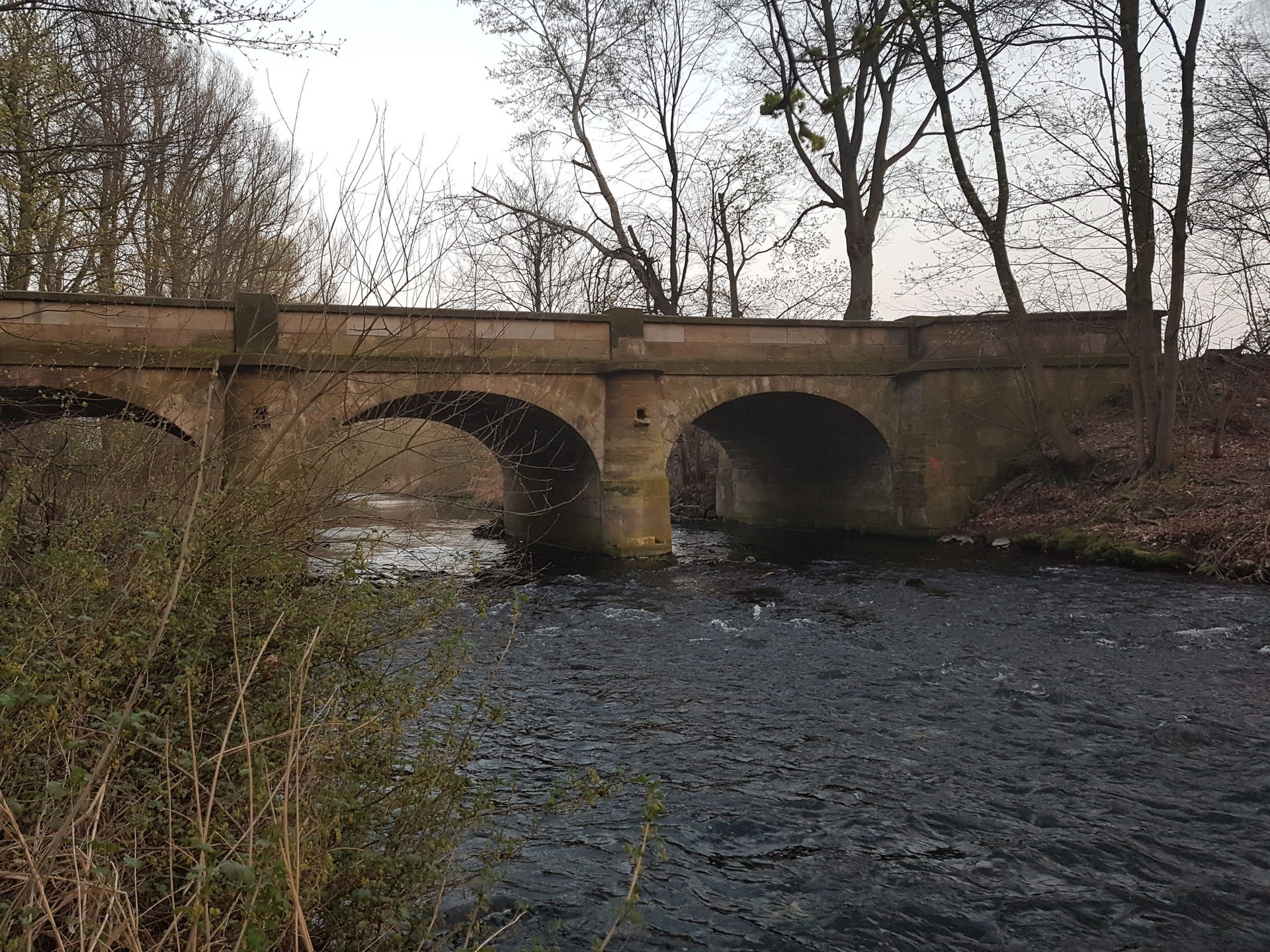
Keystone of the central arch with year of construction 1866
In 1818/19, the emergency construction gave way to a stone bridge, which was built under the direction of the Kingdom of Hanover. A third arch was added to the bridge. Each of the three large cage arches had a clear span of 19½ feet and was 8 feet above the base at the apex. The cost was estimated at 3,678 Reichstaler. The bridge was opened to traffic shortly before the end of 1819.
After a heat storm over the northwest Harz on June 29, 1861, the water once again backed up at the Franzosenbrücke, which led to flooding in the surrounding area and made the road to Lutter impassable. The main cause was considered to be the bridge's narrow openings. It was therefore decided to completely dismantle the existing stone bridge, deepen the riverbed by 5 feet and rebuild the bridge with abutments raised by 4 feet. The keystone of the middle bridge arch, which bears the date 1866, is a reminder of this reconstruction.
Renovation work 1987/88 and 2004
Extensive restoration work was carried out in 1987/88. The main measures included the expansion of the river bed to secure the foundation and the consolidation of the river bed, the securing of the piers below and above the water surface, the repair of the sandstone material used and the restoration of the road surface. The estimated costs amounted to 162,000 DM.
During the renovation work carried out in 2004, the sandstone surfaces were repaired and damaged parapet walls and their covers were renewed.
Level marking on the south pillar
A level mark can be seen on the southern bridge pier, divided into feet and inches. Measurements show that the foot here has a length of 29.2 cm. In particular, the division into 10 inches instead of the usual 12 inches per foot indicates that this is probably an old Bavarian foot and inch measure. The adoption of Bavarian measurements dates back to the time when the Wittelsbachs were not only the ruling princes of Bavaria, but also Electors of Cologne and thus rulers of the Prince-Bishopric of Hildesheim, to which the region belonged at the time.
Current use (2020)
In 1964/65, the district of Wolfenbüttel built two new bridges about 300 m south of Hohenrode when federal highways 6 and 248 were relocated. The former B 248 was then downgraded to district road 32. The old Franzosenbrücke bridge and the neighboring bridge over the Mühlengraben are still used for local traffic.
Source: Published with the kind permission of Ortsheimatpfleger Hohenrode, Markus Schulze (February 2020).